![](/images/other/stat-length.png)
![Randonnée Marche Pont de Montvert - Sud Mont Lozère - #8 GR70 La Tour du Viala - Florac - Photo](https://media.geolcdn.com/t/1900/400/ext.pjpeg?maxdim=2&url=https%3A%2F%2Fstatic1.geolcdn.com%2Fsiteimages%2Fupload%2Ffiles%2F1553511878bg_sport_marche.png)
#8 GR70 La Tour du Viala - Florac
magalette
Utilisateur
![Longueur](/images/other/stat-length.png)
Longueur
22 km
![Altitude max](https://static1.geolcdn.com/siteimages/upload/files/1508320355ic_sort_altitude_max_24dp.png)
Altitude max
1421 m
![Dénivelé positif](https://static1.geolcdn.com/siteimages/upload/files/1508320355ic_sort_den_pos_24dp.png)
Dénivelé positif
585 m
![Km-Effort](/images/other/stat-length.png)
Km-Effort
31 km
![Altitude min](https://static1.geolcdn.com/siteimages/upload/files/1508320355ic_sort_altitude_min_24dp.png)
Altitude min
536 m
![Dénivelé négatif](https://static1.geolcdn.com/siteimages/upload/files/1508320355ic_sort_den_neg_24dp.png)
Dénivelé négatif
1111 m
![Boucle](https://static1.geolcdn.com/siteimages/upload/files/16400158638029165_repeat_loop_refresh_sync_direction_icon.png)
Boucle
Non
Date de création :
2014-12-10 00:00:00.0
Dernière modification :
2014-12-10 00:00:00.0
![Marche](https://static1.geolcdn.com/sitytour/trail-icons/101.png)
6h24
Difficulté : Moyen
![Scannez ce code QR pour ouvrir la randonnée dans l'application SityTrail](https://capi.geolives.com/qq0zvz2zws4bq2lad0pu/sitytour/trails/171892/qr.png?size=200)
Application GPS de randonnée GRATUITE
À propos
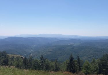
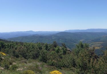
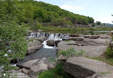
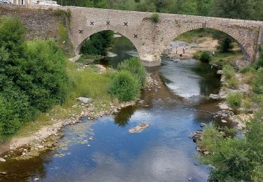
Randonnée Marche de 22 km à découvrir à Occitanie, Lozère, Pont de Montvert - Sud Mont Lozère. Cette randonnée est proposée par magalette.
Description
8ème étape de notre randonnée sur les traces de RL Stevenson entre la Tour de Viala et Florac. Etape nocturne au camping le Val des Cévennes.
Localisation
Pays :
France
Région :
Occitanie
Département/Province :
Lozère
Commune :
Pont de Montvert - Sud Mont Lozère
Localité :
Saint-Maurice-de-Ventalon
Départ:(Dec)
Départ:(UTM)
562150 ; 4909294 (31T) N.
Commentaires
Randonnées à proximité
![Randonnée Marche Pont de Montvert - Sud Mont Lozère - Montagne du Bougès - Photo](https://media.geolcdn.com/t/375/260/0f70d5f6-b995-4149-890f-c1b536613d08.jpg&format=jpg&maxdim=2)
![Marche Marche](https://static1.geolcdn.com/sitytour/trail-icons/101.png)
Montagne du Bougès
Marche
Difficile
Pont de Montvert - Sud Mont Lozère,
Occitanie,
Lozère,
France
![](/images/other/stat-length.png)
22 km | 31 km-effort
5h 42min
![](https://static1.geolcdn.com/siteimages/upload/files/16400158638029165_repeat_loop_refresh_sync_direction_icon.png)
Oui
![Randonnée Marche Pont de Montvert - Sud Mont Lozère - Bédoues saint jean du Gard GR70 gr43 - Photo](https://media.geolcdn.com/t/375/260/c8a87bd6-9939-4680-8373-9b7fd4cfe94c.jpg&format=jpg&maxdim=2)
![Marche Marche](https://static1.geolcdn.com/sitytour/trail-icons/101.png)
Bédoues saint jean du Gard GR70 gr43
Marche
Très difficile
Pont de Montvert - Sud Mont Lozère,
Occitanie,
Lozère,
France
![](/images/other/stat-length.png)
86 km | 120 km-effort
26h 6min
![](https://static1.geolcdn.com/siteimages/upload/files/16400158638029165_repeat_loop_refresh_sync_direction_icon.png)
Non
![Randonnée Marche Pont de Montvert - Sud Mont Lozère - Stevenson pont de Monvert/ Bedouès - Photo](https://media.geolcdn.com/t/375/260/ecbe7c42-7ae5-463d-8ef8-0e93073f446d.jpg&format=jpg&maxdim=2)
![Marche Marche](https://static1.geolcdn.com/sitytour/trail-icons/101.png)
Stevenson pont de Monvert/ Bedouès
Marche
Difficile
Pont de Montvert - Sud Mont Lozère,
Occitanie,
Lozère,
France
![](/images/other/stat-length.png)
26 km | 38 km-effort
7h 29min
![](https://static1.geolcdn.com/siteimages/upload/files/16400158638029165_repeat_loop_refresh_sync_direction_icon.png)
Non
![Randonnée Marche Pont de Montvert - Sud Mont Lozère - 13-05-2023 E8 Le Pont de Monvers - Bédouès - Photo](https://media.geolcdn.com/t/375/260/e57cdaa9-bdeb-4cef-90ee-76cf38da3fbe.jpg&format=jpg&maxdim=2)
![Marche Marche](https://static1.geolcdn.com/sitytour/trail-icons/101.png)
13-05-2023 E8 Le Pont de Monvers - Bédouès
Marche
Très difficile
Pont de Montvert - Sud Mont Lozère,
Occitanie,
Lozère,
France
![](/images/other/stat-length.png)
25 km | 37 km-effort
8h 19min
![](https://static1.geolcdn.com/siteimages/upload/files/16400158638029165_repeat_loop_refresh_sync_direction_icon.png)
Non
![Randonnée Marche Pont de Montvert - Sud Mont Lozère - Signal du Ventalon - Photo](https://media.geolcdn.com/t/375/260/7301b799-eab0-43e1-a503-e72b81bfeb12.jpg&format=jpg&maxdim=2)
![Marche Marche](https://static1.geolcdn.com/sitytour/trail-icons/101.png)
Signal du Ventalon
Marche
Moyen
Pont de Montvert - Sud Mont Lozère,
Occitanie,
Lozère,
France
![](/images/other/stat-length.png)
17,8 km | 24 km-effort
4h 13min
![](https://static1.geolcdn.com/siteimages/upload/files/16400158638029165_repeat_loop_refresh_sync_direction_icon.png)
Oui
![Randonnée Marche Pont de Montvert - Sud Mont Lozère - J6 Stevenson: Pont de Monvert - Cassagnas - Photo](https://media.geolcdn.com/t/375/260/ext.jpg?maxdim=2&url=https%3A%2F%2Fstatic1.geolcdn.com%2Fsiteimages%2Fupload%2Ffiles%2F1553511878bg_sport_marche.png)
![Marche Marche](https://static1.geolcdn.com/sitytour/trail-icons/101.png)
J6 Stevenson: Pont de Monvert - Cassagnas
Marche
Moyen
(1)
Pont de Montvert - Sud Mont Lozère,
Occitanie,
Lozère,
France
![](/images/other/stat-length.png)
19,7 km | 29 km-effort
5h 58min
![](https://static1.geolcdn.com/siteimages/upload/files/16400158638029165_repeat_loop_refresh_sync_direction_icon.png)
Non
![Randonnée Marche Pont de Montvert - Sud Mont Lozère - 30 pont Tarn 6 /5/24 - Photo](https://media.geolcdn.com/t/375/260/7d800b0f-50cc-4008-98c4-8c5492592e92.jpg&format=jpg&maxdim=2)
![Marche Marche](https://static1.geolcdn.com/sitytour/trail-icons/101.png)
30 pont Tarn 6 /5/24
Marche
Très difficile
Pont de Montvert - Sud Mont Lozère,
Occitanie,
Lozère,
France
![](/images/other/stat-length.png)
22 km | 27 km-effort
6h 11min
![](https://static1.geolcdn.com/siteimages/upload/files/16400158638029165_repeat_loop_refresh_sync_direction_icon.png)
Oui
![Randonnée Marche Pont de Montvert - Sud Mont Lozère - Etape 7 Pont Montvert/Florac - Photo](https://media.geolcdn.com/t/375/260/d53331d3-ea52-42ac-8b50-285688f12aaa.jpg&format=jpg&maxdim=2)
![Marche Marche](https://static1.geolcdn.com/sitytour/trail-icons/101.png)
Etape 7 Pont Montvert/Florac
Marche
Très difficile
Pont de Montvert - Sud Mont Lozère,
Occitanie,
Lozère,
France
![](/images/other/stat-length.png)
30 km | 42 km-effort
7h 56min
![](https://static1.geolcdn.com/siteimages/upload/files/16400158638029165_repeat_loop_refresh_sync_direction_icon.png)
Non
![Randonnée Marche Pont de Montvert - Sud Mont Lozère - Bédouès - Photo](https://media.geolcdn.com/t/375/260/7d170f5d-85c6-4bc9-b454-044dad9501d1.jpg&format=jpg&maxdim=2)
![Marche Marche](https://static1.geolcdn.com/sitytour/trail-icons/101.png)
Bédouès
Marche
Très difficile
Pont de Montvert - Sud Mont Lozère,
Occitanie,
Lozère,
France
![](/images/other/stat-length.png)
24 km | 36 km-effort
7h 51min
![](https://static1.geolcdn.com/siteimages/upload/files/16400158638029165_repeat_loop_refresh_sync_direction_icon.png)
Non